Botswana Safari
All images are the property of mongabay.com (Nancy Butler), copyright 1994.
Contact mongabay regarding use and reproduction.Recommended travel guides on Botswana
Recommended travel guides on Botswana: 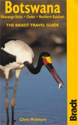

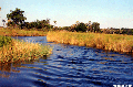
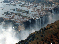
Formerly the British protectorate of Bechuanaland, Botswana adopted its new name upon independence in 1966. Four decades of uninterrupted civilian leadership, progressive social policies, and significant capital investment have created one of the most dynamic economies in Africa. Mineral extraction, principally diamond mining, dominates economic activity, though tourism is a growing sector due to the country's conservation practices and extensive nature preserves. Botswana has the world's highest known rate of HIV/AIDS infection, but also one of Africa's most progressive and comprehensive programs for dealing with the disease. [CIA World Factbook] Kalahari [Wikipedia]: The Kalahari Desert is a large, arid to semi-arid sandy area in southern Africa that covers about 500,000 km². It covers 70% of Botswana, and parts of Zimbabwe, Namibia and South Africa. Some sources extend the area of the Kalahari to over 2.5 million square kilometres and include Gabon, Republic of the Congo, the Democratic Republic of the Congo, Angola, and Zambia. The Kalahari has vast areas covered by red-brown sands and no permanent surface water. Drainage is by dry valleys, seasonally inundated pans, and the large salt pans of the Makgadikgadi Pan in Botswana and Etosha Pan in Namibia. However, the Kalahari is not a true desert. Parts of the Kalahari receive over 250 mm of erratic rainfall annually and are quite well vegetated; it is only truly arid in the south-west (under 175 mm of rain annually) making the Kalahari a fossil desert. Summer temperatures in the Kalahari range from 20 to 40 °C. In winter, the Kalahari has a dry, cold climate with frosts at night. The average low winter temperature can be below 0 °C. The Kalahari has a number of game reserves - the Central Kalahari Game Reserve (CKGR, the world's second largest protected area), Khutse Game Reserve and the Kgalagadi Transfrontier Park. Animals that live in the region include brown hyenas, lions, meerkats, several species of antelope (including the oryx or gemsbok), and many species of bird and reptile. Vegetation in the Kalahari consists mainly of grasses and acacias but there are over 400 identified plant species present (including the wild watermelon or tsamma melon). The area is the ancestral land of the Bushmen (!Kung San) peoples. There are many distinct tribes, and they have no collective name for themselves. The names San and Basarwa are sometimes used, but the people themselves dislike these names (San is a Khoi word meaning outsider, and Basarwa a Herero word meaning person who has nothing) and prefer the name "Bushman". They are thought to have been the first human inhabitants of Southern Africa; there is evidence that they have been living there continuously as nomadic hunter-gatherers for at least twenty thousand years. The Bushmen of the Kalahari desert were first brought to the western worlds attention in the 1950s when author Laurens van der Post published his most famous work The Lost World of the Kalahari, which was also turned in to a BBC TV series. This and other later works about the Kalahari prompted the creation of the Central Kalahari Game Reserve in 1961 in order to preserve the Bushmen and their homeland. In 2002 the Botswanan government forced all the Bushmen from their lands within the borders of that country and "resettled" them in fixed encampments. The government has given several different justifications for their action: that it was for purposes of nature conservation; that it was too expensive to continue to supply the Bushmen with water (the water table had been lowered by farming and other development); that it was "to enable them to share in the wealth of the country"; that it was for their own good to become settled and "civilised". The campaign group Survival International have alleged that the real reason for the re-settlement is to clear the land for diamond mining, but a different group campaigning for the rights of the Bushmen, Ditshwanelo (the Botswanan Centre for Human Rights), dispute this, claiming that the Government's motives are altruistic but misguided. There are large coal, copper, and nickel deposits in the region. One of the largest diamond mines in the world is located at Orapa in the Makgadikgadi, northeastern Kalahari. Kalahari is derived from the Tswana word Kgalagadi, meaning "the great thirst". Victoria Falls Victoria Falls is one of the world's most spectacular waterfalls. The falls are situated on the Zambezi River, which at this point forms the border between Zambia and Zimbabwe. The falls are broad at roughly a mile (1.6 km) wide, while their height is considerable at 128 m (420 ft). They form a remarkable spectacle because of their peculiar geography the water falls into a narrow slot-like chasm, and so one can view the falls face-on. David Livingstone, the Scottish explorer, visited the falls in 1855 and named them for Queen Victoria, though they were known locally as Mosi-oa-Tunya, the "smoke that thunders." The falls are part of two national parks, Mosi-oa-Tunya National Park in Zambia and Victoria Falls National Park in Zimbabwe, and are today one of Southern Africa's major tourist draws. They are also a UNESCO World Heritage Site. Discovery The falls had of course been known to people in the nearby areas since antiquity. The earliest inhabitants of the area were the San bushmen hunter-gatherers, but their name for the falls is not known. They were followed by the Tokaleya people, who knew the falls as "Shongwe". Later, the Ndebele named them "aManza Thunqayo", and after that the Makololo gave them the name "Mosi-oa-Tunya", meaning "The smoke that thunders". The first European to see the falls was David Livingstone on 17 November 1855, during his 1852-1856 journey from the upper Zambezi to the mouth of the river. Livingstone approached them from above and landed on the island on the lip of the falls now known as Livingstone Island. Livingstone had previously been impressed by Ngonye Falls further upstream, but found the new falls much more impressive, and named them after Queen Victoria. He wrote of the falls "No one can imagine the beauty of the view from anything witnessed in England. It had never been seen before by European eyes; but scenes so lovely must have been gazed upon by angels in their flight". In 1860, Livingstone returned to the area and made a detailed study of the falls with John Kirk. Another early European visitor was the Portuguese explorer Serpa Pinto, but until the area was opened up by the building of the railway in 1905, the area was seldom visited. The falls The falls lie about midway down the course of the Zambezi, at approximately 17.925° S 25.855° E. For a considerable distance above the falls the river flows over a level sheet of basalt, in a valley bounded by low and distant sandstone hills. The river's course is dotted with numerous tree-clad islands, which increase in number as the river approaches the falls. The falls are formed as the Zambezi plummets into a narrow chasm about 120 m (400 ft) wide, carved by its waters along a fracture zone in the earth's crust. Numerous islets at the crest of the falls divide the water to form a series of falls. Over the centuries, the falls have been receding upstream, falling at different eras into numerous chasms which now form a series of sharply zig-zagging gorges downstream from the falls. The falls are extremely broad at about 1.7 km across, and the height of the cascade varies from 80 m at the right bank to 105 m in the centre - about twice the height of Niagara Falls. The falling water generates spray and mist that can rise to heights of over a mile (1.6 km), and is visible from up to 40 km (25 miles) away. The fall is broken into four parts by islands on the lip of the precipice. Close to the right bank is a sloping cataract 35 m wide called the Leaping Water, then beyond 300 m wide Boaruka Island is the main fall, about 460 m across. Livingstone Island divides the main fall from another broad channel about 530 m wide, while on the left bank of the river is the Eastern Cataract. Below the falls The only outlet to the chasm the river falls into is a narrow channel cut in the barrier wall at a point about two thirds of the distance along from the western end. This channel is about 30 m (100 ft) wide, and the whole volume of the river pours through it for 120 m before emerging into a zigzagging series of gorges about 80 km (50 miles) long which conduct the river past the basalt plateau. At the end of its first gorge, the river has hollowed out a deep pool called the Boiling Pot. About 150 m across, its surface is smooth at low water, but at high water is marked by slow, enormous swirls and heavy boilings. As the river exits the Boiling Pot, the channel turns sharply westward and enters the next of the zigzagging gorges. The walls of the gorges are over 120 m high. Flow variations In the wet season, the river discharges as much as 9,100 m³/s (320,000 ft³/s) of water. At this time, the water rolls over the main falls in an unbroken expanse. The dry season may see the falls diminish to just a few narrow cascades, with the spray and mist almost absent and the flow reduced to as little as 350 m³/s (12,500 ft³/s). At this time it is possible to look into the normally obscured depths of the gorge. The level of the river in the gorge varies by up to 20 metres between maximum flow in April and the end of the dry season in October. The railway bridge Just below the Boiling Pot, and almost at right angles to the falls, the gorge is spanned by a bridge, one of only four over the Zambezi river, which was completed in April 1905 and was initially intended as a link in Cecil Rhodes' Cape to Cairo railway scheme. The bridge is 250 metres across, with a main arch spanning 150 metres, and the top of the bridge is 125 metres above the low-water level of the river. Today, regular rail services connect the towns of Victoria Falls and Livingstone with Bulawayo via the bridge, with another line running from Livingstone to Lusaka. Tourism Before the railway link to Bulawayo was completed in 1905, the falls were not much visited. They were an increasingly popular attraction during British colonial rule of the area and in the years immediately following the independence of Zambia and Zimbabwe, but from the late 1960s onwards visitor numbers dropped, as guerrilla warfare in Zimbabwe and a climate of suspicion of foreigners under the rule of Kenneth Kaunda in Zambia deterred tourists. The 1980s saw a renewed surge in tourism, and the development of the region as a centre for extreme sports played a large role in this. By the end of the 1990s, almost 300,000 people were visiting the falls annually, and this was expected to rise to over a million in the next decade. However, the number of tourists visiting Zimbabwe began to decline in the early 2000s as civil unrest brewed surrounding the continuing rule of Robert Mugabe. The numbers of people visiting the Zimbabwe side of the falls has historically been much higher than the number visiting the Zambia side, due to the greater development of the visitor facilities there. The two countries permit tourists to make day trips from one side to the other without the necessity of obtaining a visa. |